 Live Music Archive
 Librivox Free Audio
 Metropolitan Museum
 Cleveland Museum of Art
 Internet Arcade
 Console Living Room
 Books to Borrow
 Open Library
 TV News
 Understanding 9/11
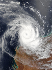
Tropical Cyclone Monty
Item Preview

Monty_tmo2004060.jpg
The MODIS instrument onboard NASA's Terra satellite captured this true-color image of Tropical Cyclone Monty located 165 kilometers north-west of Karratha. At the time of this image, Monty was travelling down the coast at 12 kilometers an hour. A category 4 storm, communities from Onslow to Barrow Island were on "blue alert" as they were in the path of predicted destructive winds with gusts of up to 240 kilometers an hour. Sensor: Aqua/MODIS.

Reviews
There are no reviews yet. Be the first one to
write a review.


